

What Is Marine Spatial Planning (MSP)?
Marine spatial planning is a comprehensive and integrated approach to managing human uses and activities in the marine environment. MSP allows for coordination between all ocean and coastal users, draws upon the best available science, and creates an inclusive decision-making process that carefully considers economic, social, ecological, and cultural interests.
Washington’s four coastal counties account for 331,000 acres of marine waters and over 3.7 million feet of shoreline. Coastal communities have a rich history and maintain a unique relationship to coastal resources. Yet there are increasing demands on these resources, including new uses that create potential conflicts. It is our responsibility to coordinate our approach to understanding and managing our resources. Marine Spatial Planning provides a way to determine the most appropriate locations for particular uses.
The Need for Marine Spatial Planning
Washington State already manages a number of human activities such as marine transportation, aquaculture, and fishing in marine coastal waters. Washington State is addressing a need for integrated and coordinated management. Marine Spatial Planning is a future-oriented process that integrates existing marine resource management and addresses emerging issues and new uses, like renewable energy. Creating a plan now provides an opportunity for all users to have input through a public planning process while determining the most appropriate strategies to manage resources into the future.
How can Marine Spatial Planning improve management of our marine resources?
Washington state agencies already manage different aspects of marine uses and resources. However, this approach to management has often failed to comprehensively address the overall health and use of marine resources in a coordinated manner.
Marine spatial planning is a process to improve and align decisions for marine waters in a comprehensive plan with common goals and shared outcomes. It has a unique focus on a wide range of mapping information to guide decisions. As a result, MSP can integrate and complement existing resource management and improve data used for decision-making.
What will a Marine Spatial Plan “look” like in Washington State?
A final plan depends on the management needs, goals, and objectives identified in the planning process. In 2013, stakeholder groups, local, state, and federal agencies, and tribes drafted the preliminary goals and objectives for planning Washington’s Pacific Coast. For more information, see the list of MSP goals, with their associated objectives and actions, and the SEPA document.
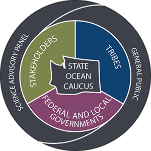
Who is involved in MSP?
- Go to “About Us” for MSP Planning team information.
- Click on the diagram below for information on each MSP participant type.
Get Involved
Public input is fundamental to create a marine spatial plan for Washington. Please join the process! Check out the events calendar for opportunities to be involved in the planning process. Some of these opportunities include stakeholder workshops, surveys, public meetings and events, information sessions, participation with the Washington Coastal Marine Advisory Council (WCMAC), or a coastal Marine Resource Committee, and the ability to provide comments every step of the way. If you would like to get up-to-date information and be added to our mailing list, please sign up here.
To send a message directly to Washington state’s MSP planning committee, fill out the form under Contact Us.
Resources
Check out the Resources page for planning materials including draft plan documents, reports to the Washington State Legislature, videos, and more! Other key questions are addressed by this Marine Spatial Planning: Frequently Asked Questions document and are updated regularly through the MSP News blog.